(Geography) ICSE Class X Important Questions : Geography (1999)
Disclaimer: This website is NOT associated with CBSE, for official website of CBSE visit - www.cbse.gov.in
Paper : ICSE Class X Important Questions : Geography (1999)
General Instructions
-
Section A is compulsory. All questions from Section A are to be attempted.
-
Answer any two questions from Section B,answer any two questionsfrom Section C and Section D. The intended marks for questions or parts of questions are given in brackets.
SECTION - A
Attempt all questions from this Section.
Question 1
Study the extract of the Survey of India Map Sheet No. 45 D/ 7 and answer the
following questions.
(a) What are the conventional signs located at the points, the six-figure grid references of which are:
-
992824
-
989775. [2]
(b) What is the area (in square kilometres) of the region enclosed by Eastings 92 and 96; Northings 78 and 82? [2]
(c) What is the compass direction of Bantawada (9978) from Arniwada (9481)? [1]
(d) Give a reason, why the streams in grid square 9478 do not join the river? [1]
(e) Generally, in which direction does the Balaram Nadi flow? Which bank of the main river does it join? [2]
(f) What special feature is depicted by the contour pattern in the following grid squares?
-
9185;
-
9785;
-
9977. [3]
(g) Name the geographical feature represented by the brown dots in the southern region of the map extract. [1]
(h) Why is there no habitation in the North-West Corner of the map? [1]
(i) In what way is the pattern of settlement in grid square 9886 different from that in grid square 9580? [1]
(j) Measure in kilometres the length of the cart-track linking Arniwada to Juvol from the point, the six-figure grid reference of which is 944816 to the point grid reference of which is 923826. [1]
(k) What difference do you observe in the pattern of drainage in grid square 9684 and the drainage in grid square 9782? [2]
(l) In grid square 9379, there is the number 217. What does this indicate? [1]
(m) What is the general land use of:
-
Uneven ground,
-
Even ground? [2]
SECTION - B
Attempt any two questions from this Section.
Question 2
On the outline map of Asia provided:

(a) Mark and name the Caucasus Mountains. [1]
(b) Mark and label the river Irrawaddy. [1]
(c) Shade and name the Sea of Okhotsk. [1]
(d) Mark and name the Kunlun Mountains. [1]
(e) Shade and name the Northern Lowlands. [1]
(f) Shade and label the Caspian Sea. [1]
(g) Shade and name the Deccan Plateau. [1]
(h) Mark and name the river Ob. [1]
(i) Shade and name the country Japan. [1]
(j) Mark and name the Great Plain of China. [1]
Question 3
On the outline map of Asia provided:
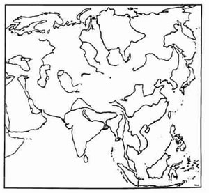
(a) Shade and label the Philippines. [1]
(b) Mark and name the Euphrates River. [1]
(c) Mark with a bold line and label the Elburz Mountains. [1]
(d) Shade and label the Tarim Basin. [1]
(e) Mark with an arrow and label Vietnam. [1]
(f') Label the river Lena. [1]
(g) Shade and name the South China sea. [1]
(h) Mark and name the Arakan Yoma range. [1]
(i) Print MN over an area which has a Monsoon type of climate. [1]
(j) Print JV over Java. [1]
Question 4
On the outline map of Asia provided:

(a) Mark in brown and name the Ural Mountains. [1]
(b) Label the river Indus. [1]
(c) Shade and label the Arabian Sea. [1]
(d) Label the river Mekong. [1]
(e) Indicate with an arrow and name the island of Borneo. [1]
(f) Print CONIFEROUS over an area where this type of forest covers a large territory. [1]
(g) Mark and name the plateau of Iran. [1]
(h) Mark with a dot and name Singapore. [1]
(i) Shade and label the largest region of Hot desert type of climate. [1]
(j) Shade and name the Indo-Gangetic Plain. [1]
SECTION - C
Attempt any two questions from this Section.
Question 5
On the outline map of the Indian sub-continent provided:
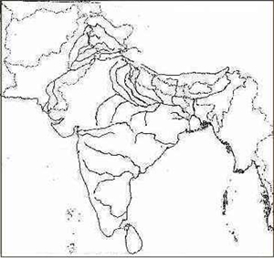
(a) Shade and name the Rann of Kutchh. [1]
(b) Mark and name the Nilgiris. [1]
(c) Mark and label the Narmada river. [1]
(d) Shade and label the Aravalli Hills. [1]
(e) Mark and name the Bombay High Oil Field. [1]
(f') Shade an area of rubber cultivation in India. [1]
(g) Mark and name a coalpeld in Orissa. [1]
(h) Mark with a dot and name Delhi. [1]
(i) Write SP over an area in North-East India which is sparsely populated. [1]
(j) Mark with a dotted line and name the Tropic of Cancer. [1]
Question 6
(a) Give the latitudinal and longitudinal extent of the Indian sub-continent. [2]
(b) Give two reasons why Jaipur has a higher annual range of temperature than Mumbai. [2]
(c) (i) Which winds are responsible for the rainfall experienced over the greater part of the Indian sub-continent? [1]
(ii) During which months ofthe year is this rainfall experienced? [1]
(d) (i) What are 'Western Disturbances'? [1]
(ii) Name two states that experience these 'Western disturbances'. [1]
(e) What is meant by Kal Baisakhi? [2]
Question 7
(a)
-
Why is laterite soil unsuitable for agriculture? [1]
-
Name one state where this soil is found. [1]
(b) (i) Which soil do you associate with the Deccan trap? [1]
(ii) State one of the advantages of this soil. [1]
(c) State two methods of soil conservation. [2]
(d) (i) Name two regions where the Tropical Evergreen Rain Forests are found. [1]
(ii) Name two important trees of this forest. [1]
(e) (i) Name two states in India where Thorn and Scrub vegetation is found. [1]
(ii) In what rainfall conditions are these forests found? [1]
SECTION - D
Attempt any two questions from this Section.
Question 8
(a) Name the months when the Kharif crops are: [1]
-
Sown,
-
Harvested.
(b) (i) Give two geographical requirements for growing Jowar in India. [2]
(ii) Name the state that leads in the cultivation of Jowar. [1]
(c) What two conditions favour the growth of tea in the Nilgiris? [1]
(d) State the soil and water requirements of Jute and name the state which is the leading producer of jute. [2]
(e) (i) Give two main varieties of tobacco cultivated in India. [1]
(ii) Which state is the largest producer of tobacco in India? [1]
Question 9
(a) [2]
-
Name two Iron and Steel Plants which have been set-up in India by two different foreign collaborators.
-
Name the regions from where coal and iron ore are obtained by these two steel plants named by you.
(b) Name the raw materials required for the cement industry. [2]
(c) Name four important products of the Heavy Chemical Industry. [2]
(d) Name one commercial product obtained from each of the following: [2]
-
Bagasse
-
Molasses.
Question 10
(a) Give two reasons why the cotton textile industry has developed around Mumbai. [1]
(b) State one town famous for each of he following cottage industries: [1]
-
Woollen shawls
-
Bidriware.
(c) Name two states where tube-wells are used extensively. [2]
(d) Name two important canal systems each in U .P. and Punjab. [2]
(e) Name the four important dams of the Damodar Valley project. [2]
(f) (i) Mention two non-conventional sources of power. [1]
(ii) Name two centres of nuclear power generation in India. [1]