(Geography) ICSE Class X Important Questions : Geography (1998)
Disclaimer: This website is NOT associated with CBSE, for official website of CBSE visit - www.cbse.gov.in
Paper : ICSE Class X Important Questions : Geography (1998)
General Instructions
- Section A is compulsory. All questions from Section A are to be attempted.
- Answer any two questions from Section B,answer any two questionsfrom Section C and Section D. The intended marks for questions or parts of questions are given in brackets.
SECTION - A
Attempt all questions from this Section.
Question 1
(a) You are on a map reading exercise in the area covered by the given map: [2]
- Give the height of the highest point on the map.
- Give the reference square in which that point is located.
(b) Name the most important perennial source of irrigation shown on the map extract. [1]
(c) On the map, what does the following indicate: [1]
- Green-wash
- Yellow-wash.
(d) What is the area (in square kilometres) of the region enclosed by Eastings 04 and 08 and Northing 02 and 06? [1]
(e) Suppose you walk along the metalled road at a speed of 1 kilometre per hour from the point where a cart track crosses the metalled road at grid reference 097068, (near Pipliya appearing on the East margin) to the distance stone numbered 19, how much time will you take to reach your destination? Write you answer in hours and minutes. [1]
(f) Name the geagraphical feature represented by white patches in the middle of Sipu Nadi. [2]
(g) Give the six-figure grid reference of the 'lined perennial well' South-West of settlement Goreli. [1]
(h) In what respect does the settlement shown in grid square 0308 differ from the settlement in grid square 0603? [1]
(i) What is the main occupation of the people living in the area shown in the map extract? [1]
(j) Express the meaning of 1 : 50,000 printed below the map extract. [1]
(k) What does 3r written in the tank in grid square 0201 indicate? [1]
(l) Name two types of vegetation in the given map extract. [2]
(m) What difference do you notice in the drainage patterns between the streams in grid square 0706 and the streams in grid square 0704? [1]
(n) Give the compass direction of Sibhra Khera (027037) from Rampura Khera (074073). [1]
(o) Measure the distance in kilometres and metres, as the crow flies from the temple in grid square 0404 to the temple in grid square 0308. [1]
(p) There are two artificial pools in the given map extract (supposing them to be carrying water) at grid references 063078. If a pipe is laid connecting these two tanks, state whether the water will flow from tank A to B or from B to A. Give a reason for your answer. [2]
SECTION - B
Attempt any two questions from this Section.
Question 2
On the outline map of Asia, provided:
(a) Shade and label Aral Sea. [1]
(b) Locate with a dot and name Djakarta. [1]
(c) Mark and name the latitude of 23½ ° North. [1]
(d) Label the river Indus. [1]
(e) Mark with an arrow and name Turkey. [1]
(f) Shade over a suitable area and print 'Temperate Mixed Forest'. [1]
(g) Mark with a bold line and label the 'Khingan Mountains'. [1]
(h) Shade and insert an arrow to show the Yellow Sea. [1]
(i) Colour and label the area representing 'Black Sea'. [1]
(j) Shade and name the Tibetan Plateau. [1]
Question 3
On the outline map of Asia, provided:
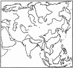
(a) Shade and circle in a pencil the island of Mindanao. [1]
(b) Mark with a bold line and label the Elburz Mountains. [1]
(c) Mark with a bold line and name Hindukush Mountains. [1]
(d) Shade and name the Sea of Japan. [1]
(e) Mark with a dot and name the capital city of Myanmar. [1]
(f) Mark with a dot and name the capital city of Sri Lanka. [1]
(g) Mark and name the latitude zero degree. [1]
(h) Shade and name the Plateau of 'Shan'. [1]
(i) Label the river Yenisey. [1]
(j) Shade and label the 'North China Plain'. [1]
Question 4
On the outline map of Asia, provided:

(a) Shade and name the sea where typhoons occur. [1]
(b) Mark with a dot and name the capital of South Korea. [1]
(c) Shade on a suitable area and print 'Equatorial Forest'. [1]
(d) Label the river Amur. [1]
(e) Mark name and number the latitude where there is 24-hours day light on Junes 21st. [1]
(f) Mark with a dot and name Dhaka. [1]
(g) Mark and name 'Mongolian Plateau'. [1]
(h) Shade and label the area representing the Asian Tundra. [1]
(i) Mark with a bold line the mountain range 'Caucasus'. [1]
(j) Shade and name the Plains of West Siberia. [1]
SETION - C
Attempt any two questions from this Section.
Question 5
On the outline map f the Indian sub-continent, provided:
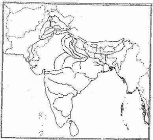
(a) Mark with a thick line and name the Sulaiman Mountains. [1]
(b) Indicate with a cross (x) the location of 'Lahore'. [1]
(c) Label the river Cauvery. [1]
(d) Mark with inverted brackets ] [ and name the location of Bolan pass. [1]
(e) Print 'DMF' in one area that has Deciduous Monsoon Forest. [1]
(f) Mark with a dot and name the city Thiruvananthapuram in the appropriate ace. [1]
(g) Print 'TEA' over one area, where it is cultivated north of the Tropic of Cancer in India. [1]
(h) Mark and name the longitude from which India takes its standard time. [1]
(i) Shade and label one important cotton growing region below the Tropic of Cancer. [1]
(j) Shade and write 'SP' over one area of sparse population in Northern India. [1]
Question 6
(a) Why does Kanyakumari experience an equable climate? [1]
(b) State two important characteristic features of monsoon rainfall in India. [1]
(c) Give one reason for the following: [3]
- Chennai has lower annual range of temperature than Lucknow.
- Shillong gets less than 200 cm of rainfall in the year while Cherapunji receives more than 1250 cm of rainfall.
- Thar Desert gets very little rain.
(d) What is the cause of winter showers in Western Uttar Pradesh and Punjab? [1]
(e) Give one reason to justify that the Himalayas act as a 'Climatic Divide'. [1]
(f) Why does central Maharashtra have only a light rainfall? [1]
(g) If we take India's North-South extent as 8° and 37° North Latitudes: [2]
- How many km. apart is each latitude?
- Calculate in km the North-South length of the country.
Question 7
(a) What is the difference between afforestation and reforestation? [1]
(b) Explain, why Deciduous Monsoon Forest are found on the eastern part of South India? [1]
(c) Where are dry thorn forests found in India? Name two important trees that grow in these forests. [2]
(d) Why are forests grown in and around the iron and steel cities? [1]
(e) State, how destruction of vegetation cover increases the soil erosion? [1]
(f) Name the soil which is found due to high temperature and heavy rainfall with alternation of wet and dry periods. Name two states where this type of soil is found. [2]
(g) State one feature of Mountain soil. Name two crops that can be grown on it. [2]
SECTION - D
Attempt any two questions from this Section.
Question 8
(a) With reference to the cultivation of tea in Southern India:
(i) Name one important tea growing area. [2]
(ii) Name the most important part for the export of tea. [2]
(b) Why are pulses so widely grown all over India? Give only reasons, why pulses are a good rotation crop for rice? [2]
(c) Explain briefly what is meant by the following terms: [2]
- Ratooning.
- Retting.
(d) State two important aspects of the Japanese method of rice cultivation. [1]
(e) Which State in India is the largest producer of coffee? Give two climatic conditions that favour the cultivation of coffee in that state. [2]
(f) What is meant by the term "Oil-cake"? [2]
Question 9
(a) State two economic advantages of the Handloom Industry. [2]
(b) Name one important centre in Bihar known for the manufacture of paper. [1]
(c) State one problem faced by the Cement Industry in India. [1]
(d) Give a geographical reason each for the location of the following industries:
- Shipbuilding in Vishakhapatnam. [1]
- Iron and Steel Industry at Bokaro. [1]
(e) Differentiate between 'Fine Chemicals' and 'Heavy Chemicals'. [1]
(f') Explain why: [2]
- Carpet-making as a cottage industry has developed in the Kashmir Valley.
- The pure silk Handloom industry is important in Bangalore.
(g) Name the most important raw material required for the paper industry. [1]
Question 10
(a) What is meant by an 'inundation canal'? [1]
(b) Name two manufacturing Industries aided by the Rihand Project, stating where each is located. [2]
(c) Suggest two advantages of bio-gas plants. [2]
(d) State two disadvantages of tank irrigation. [2]
(e) Mention two conditions essential for tube-wells. [1]
(f) With which multi-purpose project are the following associated: [2]
- Govind Sagar
- Mahanadi
- Konar
- Kotla Hydroelectric Station.