(Geography) ICSE Class X Important Questions : Geography (2001)
Disclaimer: This website is NOT associated with CBSE, for official website of CBSE visit - www.cbse.gov.in
Paper : ICSE Class X Important Questions : Geography (2001)
General Instructions
-
Section A is compulsory. All questions from Section A are to be attempted.
-
Answer any two questions from Section B andanswer any three questionsfrom Section C.
-
The intended marks for questions or parts of questions are given in brackets.
SECTION - A
Attempt all questions from this Section.
Question 1
Study the extract of the Survey of India, Map Sheet No. 45 D/10 and answer the
following questions:
Click here for Survey of India, Map Sheet No. 45 D/10.
(a) Give the meaning of the conventional symbols printed on the map of the following six figure grid references: (i) 197036 (ii) 191116. [2]
(b) Give the four figure grid reference of one prominent example of each of the following: (i) Pipe Line in the North Eastern part of the map. (ii) Rock Outcrop, in the South Western part of the map. [2]
(c) What is the compass direction of Bageri, 2002 from Hanumanji ka Mandir, 2208? [1]
(d) Name the type of drainage pattern found in grid square 2209. [1]
(e) What are the brown lines covering most of the map extract called? What do these brown lines indicate? [2]
(f) What do the words "falls 25 m" in grid square 2307 mean? [1]
(g) (i) What would be the main source of water supply for Mt. Abu?
(ii) Give a reason for your answer. [1]
(h) There are no roads connecting Mt. Abu to the settlements in the South West. Why? [1]
(i) Calculate the area of land enclosed within Eastings 17 and 21 and Northings 05 and 09. [2]
(j) Comment on the nature of the well in grid square 1806. [1]
(k) Name any two types of forested regions mentioned in the map extract. [1]
(l) Give in kilometres the length of the entire region depicted on the map from North to South. Show your working. [2]
(m) What is the settlement pattern of the largest town on the map extract supplied to you? [1]
(n) Describe the nature of roads connecting Gautam Maharishi Mandir 2007 and Shri Vashist Ashram 2207. [1]
SECTION - B
Answer any two question from this Section.
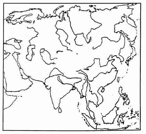
Question 2
On the outline map of Asia, provided:
-
Shade and label the Tarim Basin. [1]
-
Mark and label the River Amur. [1]
-
Shade and label the Northern Lowlands. [1]
-
Mark with a bold line and label the Elburz Mountains. [1]
-
Shade and label the largest inland sea lying between Europe and Asia. [1]
-
Shade and name the 'Tibetan Plateau'. [1]
-
Shade and name the Sea of Aral. [1]
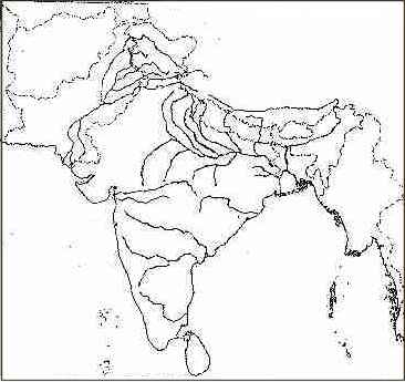
Question 3
On the outline map of the Indian sub-Continent, provided:
-
Mark and name the Mahadeo range. [1]
-
Mark and label the Chambal river. [1]
-
Shade and label the Rann of Kutchh. [1]
-
Shade and label a major coffee producing area in South India. [1]
-
Print C over one important region where copper is mined in India. [1]
-
With the help of arrow marks, name the winds that bring rainfall to the Tamilnadu coast in winter. [1]
-
Mark and name the longitude from which India takes its standard time [1]
-
Mark with a dot and name (i) Islamabad. (ii) Kolkata. [2]
-
Mark and label the Sutlej river. [1]
-
Mark and name the multipurpose project constructed on River Son. [1]
-
Shade and name a region receiving less than 50 cm of rainfall in Northern India. [1]
Question 4
(a) Which parallel of latitude divides India into the northern and southern halves? [1]
(b)
-
Name the place in India which receives the heaviest rainfall. [1]
-
Name the state where the place is located. [1]
-
Name the winds which are responsible for this heavy rainfall. [1]
-
Name two important features of the Indian Monsoon. [1]
(d) [2]
-
Name one state in India which mostly has red soil.
-
Mention two characteristics of red soil.
(e) Name one region in India for each of the following: [2]
-
Tropical Evergreen forests.
-
Thorn and Scrub forest.
(f) Explain why: [2]
-
Mumbai is warmer than Kanpur in December?
-
Account for the winter rain in northern India?
SECTION - C
Answer any three questions from this Section.
Question 5
(a)
-
What is a Rabi crop? [1]
-
Is wheat a Rabi or Kharif crop? In which state of India is the largest amount of wheat grown? [1]
(b)
-
Why are millets called 'dry' crops? [1]
-
Name any two millet crops grown widely in India. [2]
-
State two important characteristics of Indian Agriculture. [2]
(c)
-
What is Ratooning? [1]
-
Give two advantages of Ratooning. [2]
(d)
-
Name any two non-edible oilseeds grown in India. [1]
-
What is 'oil cake'? [1]
Question 6
(a)
-
Which state in India produces the largest quantity of raw cotton? [1]
-
Mention any two climatic conditions that favour the growing of cotton in the state mentioned by you in (i) above. [2]
(b)
-
What are the climatic conditions required for growing tea? [2]
-
Why is tea cultivated on hill slopes? [1]
(c)
-
Name two states which are leading producers of Tobacco in South India. [1]
-
State the economic importance of the Tobacco crop in India. [1]
-
Name the two main varieties of Tobacco cultivated in India. [1]
(d) Explain the following terms mentioning clearly the crop, they are associated with: [2]
-
Retting.
-
Ginning.
(e) Name two medicinal plants. [1]
Question 7
(a)
-
Name the foreign collaborators of the following iron and steel plant:
a. Bhillai
b. Rourkela
c. Durgapur and
d. Bokaro. [2] -
Explain the term 'mini-steel plant'. [1]
-
Give any two reasons favouring the location of iron and steel plants in North-Eastern part of Deccan. [2]
(b) Give one important centre of production for each of the following: [3]
-
Diesel Locomotive
-
Aircraft
-
Shipbuilding.
(c)
-
Name any two basic raw materials of the cement industry. [1]
-
Explain why cement is described as a basic industry. [1]
(d)
-
Why is it necessary to crush sugarcane within 24 hours of harvesting? [1]
-
Name a by product of sugar manufacture. [1]
Question 8
(a) Mention two problems faced by the cotton textile industry. [1]
(b) Give geographical reasons for the following:
-
The woollen textile industry is not as developed as the cotton textile industry in India. [2]
-
The Khadi sector of the textile industry is still very important even in this modern large-scale industrial era. [1]
(c) Name a state famous for each of the following: [2]
-
Coir Industry
-
Mulberry Silk.
(d) [2]
-
Differentiate between 'Fine Chemicals' and 'Heavy Chemicals'.
-
Name one Heavy Chemical and one Fine Chemical manufactured in India.
(e) The Bombay-Pune region is the most important industrial region of India. Substantiate the statement giving two reasons. [2]
Question 9
(a)
-
Name any two states in which Tank Irrigation is given more importance. [1]
-
State two disadvantage of Tank Irrigation. [2]
(b) Name two Thermal Power Stations associated with Damodar Valley Corporation. [3]
(c) With reference to the Hirakud Project answer the following questions. [3]
-
In which State is it located?
-
On which river has it been constructed?
-
Name two main purposes of this Project.
(d)
-
Explain the need to develop alternative sources of power in India. [1]
-
What was the main aim of setting up NTPC? [1]
-
Give two reasons why irrigation is necessary in India? [2]