(Geography) ICSE Class X Important Questions : Geography (2006)
Disclaimer: This website is NOT associated with CBSE, for official website of CBSE visit - www.cbse.gov.in
Paper : ICSE Class X Important Questions : Geography (2006)
General Instructions
- Attempt seven questions in all.
- Part I is compulsory. All questions from Part I are to be attempted
- A total of five questions are to be attempted from Part II: three questions from Section 1 and two questions from Section 2.
- The intended marks for questions or parts of questions are given in brackets.
PART I (30 Marks)
Attempt all questions from this Part.
Question 1
Study the extract of the Survey of India Map sheet No. 45D/10 and answer the
following questions:-
(a) Give the six figure grid reference of :- [2]
- the temple in village Dhavli
- Δ 480
(b) What do the following indicate? [2]
- 6r in grid square l903
- The word Brackish in grid square 1403
(c) (i) In grid square 1909 several contours merge at one point. What does this represent?
(ii) State the significance of the red dotted lines in the map extract. [2]
(d) Name the type of rainfall experienced in the region shown in the map extract. Give a reason to support your answer. [2]
(e) How does the drainage pattern in grid square 1606 differ from the drainage pattern in grid square 17087? [2]
(f) (i) What is the pattern of settlement in grid square 1904?
(ii) Name the settlement that has a post office. [2]
(g) Name two land forms represented by the pattern of contours in grid square 1608. [2]
(h) Calculate the ground distance in kilometres along the metalled road between the causeway in 1502 and the distance stone marked '14' in grid square 1203. [2]
(i) State two reasons for the absence of human habitation in the north eastern region of the map extract. [2]
(j) (i) Mention the difference in height between the highest spot height in the map extract and the contour height in grid square 1006.
(ii) What is the compass direction of Patlawa ka Goliya (590.)
from
Kacholi Dungar (443.)? [2]
Question 2
On the outline map provided:-
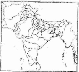
(a) Mark and name Colombo. [1]
(b) Shade and Label the Satpura Range. [1]
(c) Label the River Krishna. [1]
(d) Mark and label the Capital City of Pakistan. [1]
(e) Label the River Ravi. [1]
(f) Shade and label the Khasi Hills [1]
(g) Mark with arrows the direction of the North East Mountain winds over the Bay of Bengal. [1]
(h) Mark and label Malabar coast. [1]
(i) Shade and label an area of Laterite soil in India. [1]
(j) Shade and label an area of Limestone in India. [1]
PART II (50 MARKS)
SECTION 1
Attempt any three questions from this Section.
Question 3
(a) With reference to Pakistan name the following:-
- two neighbouring countries.
- two important crops. [2]
(b) Name the four mountain ranges radiating from the Pamir Knot. [2]
(c) State two features of the drainage of Sri Lanka. Name the water body that separates Sri Lanka from India. [3]
(d) Why is Bangladesh prone to flooding? How are the floods beneficial to the people of that country? [3]
Question 4
(a) How have the relief and climate of Nepal affected the basic occupations of the people of that country? [2]
(b) Mention two differences between the Deccan Plateau and the Baluchistan Plateau of South Asia. [2]
(c) (i) Name the countries which have a land borders with Bhutan.
(ii) Explain why none of the rivers of Bhutan are navigable but have a great potencial for hydro - electric power. [3]
(d) Distinguish between the rivers of the North Indian Plains and those of Peninsular India. [3]
Question 5
(i) Which SAARC country is the first to receive the South West Monsoons? Give a reason to justify your answer. [2]
(b) (i) Which winds are responsible for the rainfall experienced over the greater part of the SAARC countries?
(ii) During which months of the year is this rainfall experienced? [2]
(c) Give reasons for the following:-
- It is cooler on the mountain slopes than in the plains during the summer.
- Mumbai is warmer than Kanpur in December.
- Rajasthan receives very little rainfall. [3]
(c) Study the table given below and answer the questions that follow:-
| Station | Month | J | F | M | A | M | J | J | A | S | O | N | D |
| A | Temperature in Degree C. | 14.4 | 16.7 | 23.3 | 30.0 | 33.3 | 33.3 | 30.0 | 29.4 | 28.9 | 25.6 | 19.4 | 15.6 |
| Rainfall in cms | 2.5 | 1.5 | 1.3 | 1.0 | 1.8 | 7.4 | 19.3 | 17.8 | 11.9 | 1.3 | 0.2 | 1.0 | |
| B | Temperature in Degree C. | 24.4 | 24.4 | 26.7 | 28.3 | 30.0 | 28.9 | 27.2 | 27.2 | 27.2 | 27.8 | 27.5 | 25.0 |
| Rainfall in cms | 0.2 | 0.2 | 0.3 | 1.0 | 1.8 | 50.6 | 61.0 | 24.8 | 24.8 | 24.8 | 1.0 | 0. |
- Calculate the annual rainfall in station A.
- What is the annual range of temperature in station B?
- Which of the two stations has an equable climate?
Question 6
(a) State two differences between Black soil and Alluvial soil [2].
(b) Mention two ways by which soil can get nitrogen. [2]
(c) Explain the need for soil conservation in India. State two methods of soil conservation .[3]
(d) How is red soil formed? State two reasons for the low productivity of red soil.
Question 7
(a) Name one important oil field each in Bangladesh and Pakistan.
(b) Name two states in India where manganese is found. State one use of manganese. [2]
(c) Name the four types of coal. Which of these is the best for industrial purposes? justify your answer. [3]
(d) Which country in South Asia is the largest producer of bauxite? Why is bauxite considered an important mineral? [3]
SECTION 2
Attempt any two questions from this Section.
Question 8
(a) State two geographical requirements for the growth of cotton. [2]
(b) Mention two differences between shifting agriculture and plantation agriculture. [2]
(c) (i) Name two main varieties of coffee.
(ii) Why are the following trees commonly grown in a coffee estate?
(l) Dalap and Silver Oak
(2) Orange and Plum [3]
(d) State three important aspects of the Japanese method of rice cultivation. [3]
Question 9
(a) What is thermal power? Name two thermal power stations in India. [2]
(b) State two reasons why bio-gas is considered an ideal domestic fuel. [2]
(c) Mention three disadvantages of conventional sources of energy. [3]
(d) State the main purpose for which the Kosi Project was set up was set up. Name the two countries that share this project. [3]
Question 10
(a) Mention the problem faced by the Sugar industry in India. [2]
(b) State two steps taken by the government to overcome the problem faced by the jute industry in India. [2]
(c) Mention three factors that favour the concentration of the cotton textile mills in Mumbai. [3]
(d) State three reasons why the woollen textile industry has not developed in India. [3]
Question 11
(a) (i) State the importance of Electronics in Defence.
(ii) Mention one important requirement of the Electronics industry. [2]
(b) State two advantages of Mini Steel Plants. [2]
(c) (i) State two geographical factors which were taken into consideration for the setting up of the Durgapur Iron and Steel Plant.
(ii) Mention any one problem faced by the Iron and Steel industry in India. [3]
(d) Name the following in India:-
- A product of the heavy engineering industry.
- Two petrochemical units.
- A centre of the silk industry. [3]