(Geography) ICSE Class X Important Questions : Geography (2000)
Disclaimer: This website is NOT associated with CBSE, for official website of CBSE visit - www.cbse.gov.in
Paper : ICSE Class X Important Questions : Geography (2000)
General Instrutions
- Section A is compulsory. All questions from Section A are to be attempted.
- Answer any two questions from Section B and answer any three questionsfrom Section C. The intended marks for questions or parts of questions are given in brackets.
SECTION - A
Attempt all questions from this Section.
Question 1
Study the extract of the Survey of India Map Sheet No. 45 D/ 7 and answer the
following questions.
Click here for Survey of India Map Sheet No. 45 D/ 7.
(a) Give the meaning of the following conventional signs:
- The blue spot in village Kheda in the South-west corner of the map.
- The irregular black lines along the Sarod Nala in the square whose four-figure grid reference is 8284. [2]
(b) State three advantages that Dantiwada (South of River Banas) has over other settlements in the region. [2]
(c) How are (i) Cultivated land and (ii) Wooded land represented on the map? [1]
(d) Assuming that you can see upto had a kilometre on either side of the cart track, describe the journey by motor-car from Dantiwada in grid square 8480 to Sikariya in grid square 8081 with reference to:
- Direction
- Physical Features; and
- Vegetation. [3]
(e) What is the area in square kilometres of the cultivated region enclosed by vertical grid lines 82 and 84 and the horizontal grid lines 78 and 80? [1]
(f) Give the six figure grid reference of the well approximately half a kilometre west of village Ramsida in the south-east section of the map. What is the total depth, in metres, from the top to the bottom of the well? [1]
(g) What is the main occupation of the people of the villages indicated on the map extract? [1]
(h) Give two points of contrast between the region on the right bank and the region on the left bank of the Arado Nadi. [1]
(i) What is the difference in height, in metres, between the highest point in the map and the contour height in grid square 8984? [1]
(j) In the south east part of the map, why do some of the streams not join the main. [1]
(k) What is the general habitation of human habitation (settlement) in the map extract? [1]
(l) Measure the length of the canal (under construction) in metres from the point whose six figure grid references is 804797 to the point whose six-figure grid reference is 821804. [1]
(m) What does 6r written against the unmetalled road (gravelled) in grid square 8478 mean? [1]
(n) How does the drainage pattern in grid square 8186 differ from the pattern of streams in grid square 8585? [1]
(o) Can you send a telegram from any of the villages appearing on the map? If so, write the name of one such village and the reference square in which that village is situated. [2]
SECTION - B
Attempt any two questions from this Section.
Question 2
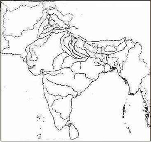
On the outline map of the Indian sub-continent provided:

(a) Label the River Ravi. [1]
(b) Mark with a thick line and name the Satpura Hills. [1]
(c) Name the River Godavari. [1]
(d) Mark with a dot and name, in the appropriate place, the capital city of Madhya Pradesh. [1]
(e) Shade and name the area where mangrove forests occur. [1]
(f) Print Uttar Pradesh in its proper location. [1]
(g) Mark with a thick line and name the Sulaiman Range. [1]
(h) Shade an area having winter rainfall in South India. [1]
(i) Print the word GOLD over one area where it is mined. [1]
(j) Draw the line of latitude 10°N which passes near Kochi (Cochin). [1]
(k) Print in bold letters 'W' in the region in Pakistan where wheat is grown and 'T' for tobacco in one region in western India where it is widely grown. [1]
(l) Shade and name the Rann of Kutchh. [1]
Question 3
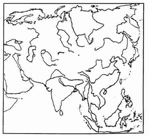
On the outline map of Asia provided:

(a) Shade and name the Plateau of Iran. [1]
(b) Mark with a thick line and name the Khingan Range. [1]
(c) Shade and label the Sumatra Island. [1]
(d) Draw an arrow to show the Persian Gulf. [1]
(e) Label the River Lena. [1]
(f') Shade a suitable area and print 'TUNDRAS'. [1]
(g) Draw and name the zero degree latitude. [1]
(h) Shade and name the Great North China Plain. [1]
(i) Circle in pencil and label the Philippines. [1]
(j) Mark with a thick line and show the Himalayas. [1]
(k) Shade and name the Sea of Okhotsk. [1]
(l) Shade and label the Plateau of Arabia. [1]
Question 4
(a)
- Name any two states that receive rain in ]anuary-February. [1]
- What causes this winter rain? [1]
- Name the vegetation type found in saline environment under tidal influence? [1]
- Name the most important tree associated with the type of vegetation you have named in (a) (iii) above. [1]
(b) Name the economically most important vegetation belt of India. [1]
(c) With reference to the red soils in India.
- Name two states where it is found. [1]
- State two disadvantages of the above named soil. [2]
- How does the soil of the Ganga-Yamuna plain differ from that of Central Maharashtra? [1]
- Which soil is found suitable for coffee cultivation in Karnataka? [1]
- Name the type of soil found on the summit of the Eastern Ghats. [1]
- Name the soil known for its self-ploughing quality and capacity to hold moisture. Name one cash crop for which it is most suited. [1]
SECTION - C
Attempt any three questions from this Section.
Question 5
(a) Name one crop each with which the following processes are associated: (i) Retting (ii) Ginning. [1]
(b) Name any two plants which ensure a supply of raw material for pharmaceutical industry. [1]
(c) After oil extraction, what other uses can the oilseed be put to? [1]
(d) Why is millet called a 'dry crop'? [1]
(e) Which state is the largest producer of tobacco in India? [1]
(f') What is 'crop rotation'? [1]
(g) Name one important plantation crop grown in India. Mention one important characteristic feature of the plantation crop named by you. [1]
(h) Give one reason for small-sized land holding in India. [1]
(i) Name two states which are leading producers of wheat in India. [1]
(j) Name one state which is an important producer of groundnut. [1]
(k) Outline two remedial steps being taken by the government to boost agricultural production. [2]
Question 6
(a) Give two reasons to explain why there is a need for rapid industrialisation in India. [1]
(b) Outline two major problems of the jute industry in India. [1]
(c) (i) Give one reason to explain why cottage industries play
an important role in India's development.
(ii) State two ways by which the government has encouraged cottage industries.
[2]
(d) Name the oldest coal held in India. [1]
(e) From where does the iron and steel plant of Bhadravati get its iron-ore? [1]
(f) Why is there an increasing demand for Handloom materials? [1]
(g) Mention one major problem of small-scale industry. [1]
(h) Copy the names of the following two places and, alongside, write the name of the most important product associated with each:
- Raniganj
- Digboi. [2]
(i) Copy the names of the following two industries and, alongside, write the name of the important state associated with each:
- Cement
- Chemical fertilizers. [2]
Question 7
(a) Irrigation is indispensable for an agricultural country like India. Give two reasons to explain why artificial irrigation is essential. [2]
(b) Irrigation in India faces many problems. Name any two. [3]
(c) On which river is the Farakka Project located? Give one important aim of this project. [1]
(d) Name one thermal power station association with each of
the following multipurpose projects:
(i) Damodar Valley Corporation (ii) Hirakund Project. [2]
(e) Name one state where tank irrigation is very important. [1]
(f) Which multipurpose project is located on the River Mahanadi? Name one important dam associated with the project named by you. [1]
(g) Irrigation through ground water is still popular despite of big river projects. Why? [1]
(h) Distinguish between:
- Inundation canal and Perennial canal
- A barrage and a dom. [2]
Question 8
(a) Give two advantages of non-conventional sources of energy. [1]
(b) Name two states where wind form projects have been undertaken. [1]
(c) Mention two advantages of producing electricity from water. [1]
(d) State the two important aims of the National Thermal Power Corporation (NT PC ). [1]
(e) Give the location of the gas-based and one coal-based thermal power project. [1]
(f) Name two raw materials used for the generation of atomic energy. [1]
(g) Mention one advantage bio-gas energy has over solar power. [1]
(h) Name the four important places where India's nuclear power plants are located. [2]
(i) Give two disadvantages of constructing large-scale hydroelectric projects. [2]
(j) Mention two example of the direct use of solar energy. [1]